There was a time when the thought of walking made me shudder.
I grew up in Merstham, a one-pub village in England's south-east that sits on the motorway border between London and Surrey. My school was at the top of a wooded hill, accessible to vehicles only by two narrow country roads. But my school commute, a journey where I was more likely to encounter a bushy-tailed squirrel than another human being, was a little different.
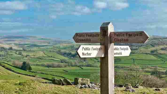
A new national network of walking routes will soon connect every town, city and thousands of villages across Britain
Most days after class, I would swap my school shoes for mud-encrusted wellies, watching with envy as my friends were whisked away in their parents' warm, dry cars. My mum was working long hours in the city and there were no public buses plying the school's narrow access roads, so I had two options: walk the two-mile bridleway that connected my village to the school; or wait until dinnertime to be picked up. The decision, despite having to trudge through shin-deep mud for 40 minutes, was an easy one.
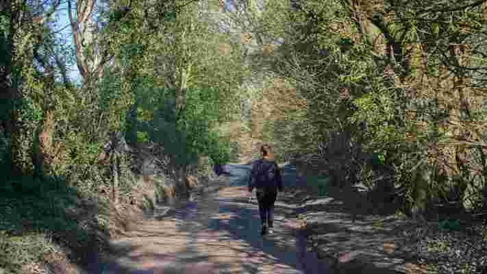
The author recently used a new national network of walking routes to explore West Sussex on foot (Credit: Jessica Vincent)
Fast forward 11 years and I was once again squelching through a muddy English footpath, only this time I was doing it for fun. It was a crisp Saturday morning without a cloud in the sky and, with few other activities available under Britain's third national coronavirus lockdown, I'd set out to explore my recently adopted home of West Sussex on foot.
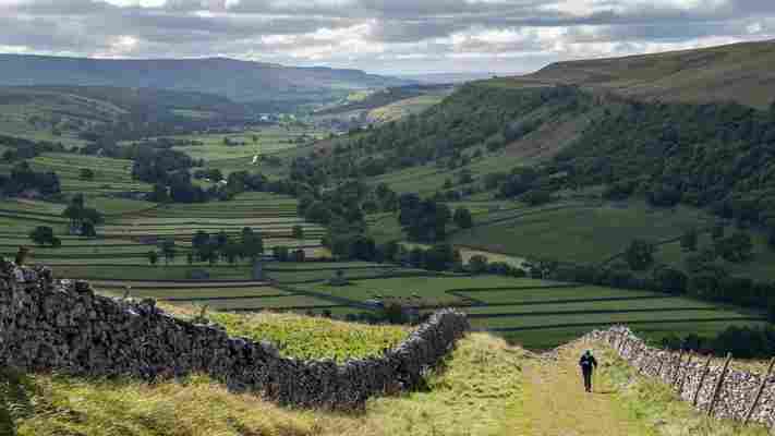
The county is well known for its beautiful National Trails, like the 100-mile-long rolling chalk hills of the South Downs Way and the windswept Seven Sisters cliff walk. But having hiked both before, I wanted to try something different. Instead, I would use the Slow Ways map – a new national network of walking routes that will soon connect every town, city and thousands of villages across Britain – to walk between Storrington and Worthing, a 10-mile route that would take me from the northern foot of the South Downs to the sea via the medieval village of Findon.
"You'll be the first to walk this route," said Daniel Raven-Ellison, a geographer, National Geographic Explorer and the founder of Slow Ways. "You must know that everything is user-generated and yet to be tested, so you'll be the guinea pig."
Despite Britain having thousands of public footpaths, there is no map showing the best way to walk between Britain's cities and towns (Credit: R A Kearton/Getty Images)
In an age when GPS has mapped the fastest way to drive, cycle or bus between almost anywhere, there is no map showing how to best walk between Britain's cities and towns. Despite Britain having thousands of public footpaths, Google Maps often leads pedestrians alongside A-roads or through private property, while walking apps usually avoid the most direct route in favour of more scenic and remote trails. In short, planning an intercity walk in Britain was, for most, more hassle than it was worth – until now.
In January 2020, Raven-Ellison put out a call on social media for volunteers to join him at an upcoming Geovation hack day in London to help with his most ambitious mapping project to date. Using existing public rights of way, the Slow Ways map would create a national slow highway showing people the safest, most direct and most enjoyable way to walk between anywhere in Britain.
For centuries, footpaths and bridleways were the only way to travel around Britain
"[The British] culture around walking means we travel on foot mostly for recreation," Raven-Ellison told me. "But what if we started using our incredible network of footpaths to walk further, more often and for more purposes?"
For centuries, footpaths and bridleways were the only way to travel around Britain. Stitched together to form an extensive pedestrian highway, these ancient paths allowed the Romans, and later the Anglo-Saxons, to trade and visit relatives in neighbouring villages. It wasn't until the 19th Century, when Romantic poets like Keats and Wordsworth waxed about the benefits of rambling, that walking for recreational purposes became popular across Britain.
Many of Britain's footpaths follow ancient paths forged by Romans and later Anglo-Saxons (Credit: john finney photography/Getty Images)
According to BBC Countryfile , today England and Wales alone have an estimated 180,000 miles of public rights of way. But that number only includes footpaths that are officially recognised. According to the walking association The Ramblers , more than 49,000 miles of rights of way are missing from the definitive map in England and Wales and are at risk of being lost forever.
"Slow Ways is a cultural invitation for people to use our existing footpaths in ways that we once did," said Raven-Ellison. "But this isn't just about reviving old rights of way. Slow Ways begins to ask questions about how we connect new cities and towns that have appeared since those ancient paths were created – it's about creating a walking network that's fit for the future."
You may also be interested in: • The tiny 'country' between England and Scotland • The war correspondent walking the world • Did the Romans really reach Scotland?
Seventy people turned up to the Geovation event, and the first 1,000 Slow Ways routes were created. But Slow Ways was suddenly brought to a halt when, less than a month later, Britain went into its first national lockdown. Raven-Ellison feared Covid-19 would stop Slow Ways in its tracks, but the virus had the opposite effect.
With the use of public transport discouraged and a stay-at-home order in place, part of the British government's official transport advice was, and still is, to walk "if possible". What followed was a walking boom: during Britain's first lockdown, online searches for urban green spaces on the Ordnance Survey's database (Great Britain's national mapping agency) spiked by 949% .
Throughout the pandemic, the British government's advice has been to walk from point A to B, if possible (Credit: Stephen Knowles Photography/Getty Images)
Harnessing Britons' renewed passion for the outdoors, Raven-Ellison put out a second call in April 2020, this time for volunteers to help create Slow Ways routes using free online mapping tools at home. Seven hundred volunteers signed up from across Britain and, just a month later, they collectively mapped 7,500 walking routes spanning 110,000km.
In one month, 700 volunteers mapped 7,500 walking routes spanning 110,000km
The second wave of volunteers participated in a one-hour Zoom training session where they learned how to chart the Slow Ways network: routes must be as direct but as off-road as possible; only use existing public rights of way or paths with permissive access; and have places to rest at regular intervals. Within weeks, a new nationwide walking network was complete, making it possible to easily plan walks between cities like Liverpool and Manchester, Cardiff and Bristol and Newquay and Plymouth for the first time ever.
"We had about a year's worth of time volunteered in a single month," said Raven-Ellison. "I couldn't believe how many people signed up, and how much time they were willing to invest in the project."
One of the first to respond to Raven-Ellison's call was Jane Taylor. "The idea of finding a slower, greener way to travel immediately appealed to me," said Taylor. "When you walk, you see more – you smell the land, you feel the countryside, and you find out the history of the area. I don't want future generations to miss out on that."
The newly mapped network makes it possible to easily plan walks between places like Liverpool and Manchester, Cardiff and Bristol and elsewhere (Credit: Charles Stirling/Alamy)
In September 2020, Raven-Ellison put out a third call for an additional 10,000 volunteers to help verify the routes were accurate and safe. "I was a bit nervous that we wouldn't get that many," he said. "But we're now up to 80,000 and counting."
Once Covid-19 restrictions lift across Britain, volunteers will walk the routes and fill out a questionnaire to assess the routes' accuracy, safety and accessibility. Raven-Ellison hopes to soon publish the map on the Slow Ways website so that as many people as possible can review and grow the network. He says the Ordnance Survey has also expressed interest in publishing it on their website and app moving forward.
The Ordnance Survey has also expressed interest in publishing this new pedestrian highway
"I see this as a massive collaborative mapping project," said Raven-Ellison. "We're creating a new footpath infrastructure not just for ourselves, but for future generations. For that we're going to need all the help we can get."
Raven-Ellison hopes Slow Ways can create a new walking network for future generations (Credit: Terry Mathews/Alamy)
With Raven-Ellison's warning still ringing in my ears, I uploaded the GPX files he'd given me to OS maps and laced up my trainers. I started early in Storrington, a 12th-Century former market town with stone walls, a medieval church and 200-year-old limestone cottages so charming they belonged in a Beatrix Potter story. I turned left onto Brown's Lane as my map instructed, passing an intricately carved Islamic-style door that looked like it belonged in a Moroccan souk rather than a rural English town, before traversing a muddy field into a country lane cocooned in a web of leafless trees and gurgling, pond-fed waterfalls.
As I emerged out of the sheltered bridleway onto open hills blooming with daffodils and dotted with lambs basking in the spring sunshine, it occurred to me that I'd driven past these fields a dozen times, yet I was smelling the land and seeing the landscape for the very first time. The footpath climbed steeply over the South Downs, the stitched canvas of green grass, brown-grey woodland and red-brick rooftops stretching out across the landscape like a patchwork quilt below. A buzzard swooped overhead while I pushed on, following the smell of cut grass and dry hay until, two hours later, I reached Findon.
In normal times I might have stopped for a West Sussex ale at the 16th-Century Village House pub, or perhaps a slice of carrot cake at Dee Dee's tea room. Everything was closed due to Covid-19 that day, but Raven-Ellison hopes that once restrictions lift, having hospitality at regular intervals will make these routes more accessible to a wider range of people. "You can get a train or bus to the start point, and eat in a Tesco or stay in a Premier Inn. Slow Ways isn't just for hikers – it's for everyone," he said.
"I'd drive past these fields a dozen times, yet I was smelling the land and seeing the landscape for the very first time" (Credit: Jessica Vincent)
I followed Findon's whitewashed high street and stone walls out into open fields once more until, an hour later, I reached the pastel-hued townhouses of Salvington and West Tarring. As the sun began to lose its warmth, the sound of pebbles crunching beneath my feet and the smell of freshly battered fish signalled the end of my journey. Ten miles and four hours later, I'd made it to Worthing's seafront.
I arrived home as I often did as a teenager returning from school: muddy, red-faced and exhausted. But a decade later, the ability to walk freely and safely between towns feels more like a privilege than a chore. In an increasingly fast-paced world, Slow Ways reminds us that putting on the brakes can often be the fastest route to a greener, healthier and, perhaps, happier life.
"Walking is good for the environment and our physical health," Raven-Ellison said. "But it also makes us more creative and more productive. What can be more powerful than that?"
---
Slowcomotion is a BBC Travel series that celebrates slow, self-propelled travel and invites readers to get outside and reconnect with the world in a safe and sustainable way.
Join more than three million BBC Travel fans by liking us on Facebook , or follow us on Twitter and Instagram .
If you liked this story, sign up for the weekly bbc.com features newsletter called "The Essential List". A handpicked selection of stories from BBC Future, Culture, Worklife and Travel, delivered to your inbox every Friday.
Leave a Comment